
Villard-Reymond and Villard-Notre-Dame loop - Hiking from Le Bourg-d'Oisans
LIEN FICHE SIT 5938296Ascent from Bourg d'Oisans to Villard Notre Dame, then the forest track to Villard-Reymond; from there back down to Bourg d'Oisans. A long walk for regular hikers. Breathtaking views.
TECHNICAL INFORMATION:
Start: 'La Fare', on the greenway between Le Bourg d'Oisans and the hamlet of St Claude (Le Vert).
Difference in altitude: 1,000 m
Duration: 8h00
Distance: 12km
Level: Difficult
MAP AND TOPO :
IGN map 3335ET
Topoguide OBP n°1
ROUTE :
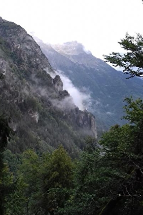
Gradual ascent through the woods to the village of Villard-Notre-Dame. Arriving at the village, the view is sublime over the aerial road to Villard-Notre-Dame, the perched village dominating the entire Romanche valley.
Once the visit to the village is over, the trail continues more openly to the next Villard: Villard-Reymond. The atmosphere is totally different, with this time a village set in a cirque and dominated by the majestic Grand Renaud. The valley is always visible from the village. Don't hesitate to stop in the little village of Villard-Reymond before the slightly steeper descent!
THINGS TO SEE ALONG THE WAY
-Villages of Villard-Reymond and Villard-Notre-Dame
-Village bell towers
En pratique
- Acceptés
Animaux acceptés
- Acceptés
Services
- Pets welcome
Informations complémentaires
Tourisme adapté
- Not accessible in a wheelchair
Langues parlées
- French
Durée moyenne d'une visite groupée
- 8h
Ouvertures
From 01/05 to 31/10.
Subject to favorable snow and weather conditions.
Périodes
- Autumn,
- Summer,
- Spring
Tarifs
Free of charge.
Go there
Latitude : 45.051786
Longitude : 6.029574
Height : 700
38520 Le Bourg-d'Oisans
Go there
Starting point: 'La Fare', on the greenway between Bourg d'Oisans and the hamlet of St. Claude.
Information mise à jour le 21/01/2025
par Oisans Tourisme
null


