
Refuge du Promontoire
LIEN FICHE SIT 122824Warning: Attempt to read property "term_id" on array in /home/isere/public_html/wp-content/plugins/sit-core/src/Templates/Services/Components/BlocSITMetas.php on line 27
Warning: foreach() argument must be of type array|object, bool given in /home/isere/public_html/wp-content/plugins/sit-core/src/Templates/Services/Components/BlocSITMetas.php on line 35
Clinging to the rocks on the ridge leading up to the Meije, it is like the prow of a ship dominating the sheer drop. It's a refuge for mountaineers, but also a wonderful excursion for seasoned hikers!
This is the refuge de la Meije, and the race begins as soon as you pass through the door (atmosphere guaranteed). Departure for the Brèche de la Meije or the mythical traverse of the Meije to the Aigle refuge.
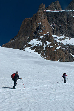
Breathtaking views over the Vallon des Etançons.
HIKING IN THE HEART OF THE ECRINS NATIONAL PARK
The Écrins massif is an exceptional area, open to all, with a rare natural, cultural and landscape heritage.
and landscapes. To protect these treasures, the heart of the park is marked with blue-white-red painted flags, where regulations must be respected. Please take note of them when preparing your hike
to preserve this collective asset on the ecrins-parcnational.fr website.
In practice
Equipments
- Defibrillator,
- Sustainable development,
- Outhouse,
- Photovoltaic panel,
- Drying area
Services
- Independently Managed,
- Full-board,
- Breakfast,
- Booking obligatory,
- Half-board,
- Restaurant,
- Picnic hampers
Comfort
- Heating,
- Fireplace / Wood burning stove,
- Bunk beds,
- Wood available,
- Duvet
Activities
- Off piste,
- Climbing,
- Climbing sports,
- Mountain climbing,
- Ski
Time schedule
Choissez une période :
From 03/22/25 to 05/03/25
-
Monday :
Open
-
Tuesday :
Open
-
Wednesday :
Open
-
Thursday :
Open
-
Friday :
Open
-
Saturday :
Open
-
Sunday :
Open
From 05/06/25 to 05/31/25
-
Monday :
Open
-
Tuesday :
Open
-
Wednesday :
Open
-
Thursday :
Open
-
Friday :
Open
-
Saturday :
Open
-
Sunday :
Open
From 06/07/25 to 09/13/25
-
Monday :
Open
-
Tuesday :
Open
-
Wednesday :
Open
-
Thursday :
Open
-
Friday :
Open
-
Saturday :
Open
-
Sunday :
Open
From 09/14/25 to 03/15/26
-
Monday :
Open
-
Tuesday :
Open
-
Wednesday :
Open
-
Thursday :
Open
-
Friday :
Open
-
Saturday :
Open
-
Sunday :
Open
Subject to snow conditions
Prices
Payment method
- Check,
- Travellers Cheque,
- Cash
From 07/06/25 to 13/09/25
- Night à régler dans le tronc ou par chèque au Comité FFCAM de l'Isère
- 8€
- Child rate per night à régler dans le tronc ou par chèque au Comité FFCAM de l'Isère
- 8€
- CAF member rate per night à régler dans le tronc ou par chèque au Comité FFCAM de l'Isère
- 8€
Tariff and discounts available at http://refugedupromontoire.ffcam.fr/tarifs.html
Réservation - Réservation obligatoire

Go there
Latitude : 44.998413
Longitude : 6.303371
Height : 3092
Go there
Public transport: By train to Grenoble train station - Coach services from Grenoble coach station to Bourg d'Oisans: 3000 service to Bourg d'Oisans via Vizille or 3030 service to Les Deux Alpes via Bourg d'Oisans. Information and timetables available at www.transisere.fr or by phone (0 820 08 38 38).
From La Bérarde: (Height gain 1380 m, duration 5h)
Walk up to the Refuge du Châtelleret (2h). From Le Châtelleret, carry on up the Étançons valley, crossing the moraines of the ancient glacier. At 2900m, you have two options:
- either the standard, easier route, going east (left uphill) to reach the foot of the glacier then going west (right) along the glacier but without walking on it, until you reach the hut. There are numerous cairns marking the way. At the beginning of the season, snow remains at the top of the ascent to the hut.
- or by a more alpine route (climbing gear essential) by climbing straight up the Promontoire ridge, which is fitted with a via-ferrata type cable.
From La Grave: (Height gain 1110 m, duration 4h30, Rating PD 3b ll P4)
By the Brèche de la Meije, north side, via the Enfetchores (hiking guide and map essential).
After the climb up to the Enfetchores, carry on to the Meije gap (3357m) then go down the south face to the Promontoire hut (belay points and abseils re-equipped in 2011).
Information mise à jour le 09/06/2025
par Club Alpin Français - FFCAM
null


