
Gorges de Sarenne en boucle - Hiking
LIEN FICHE SIT 5362714
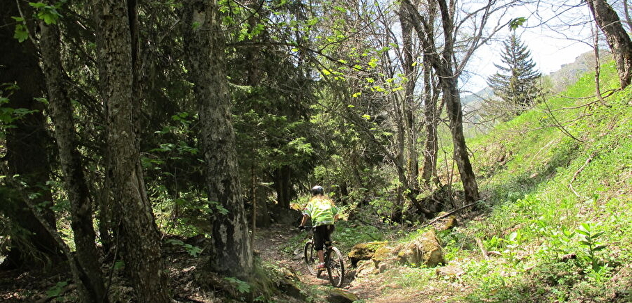
A beautiful hike that takes you through the Sarenne gorges and up the slopes of Signal de l'Homme. You'll also pass through the charming hamlet of Rosai, which is well worth a visit.
TECHNICAL INFORMATION
Start: Auris-en-Oisans
Height difference: 560 m
Round trip time: 5h
Distance : 12.5 km
MAP AND TOPO :
Map / Topo guide OBP n°2 et 3 (on sale at the tourist office): paths 301 + 290 + 265 + 252 + 339 + 253.
ITINERARY
At the entrance to the resort, take the path up towards the Col de Maronne. At the top, head down towards La Garde, then the Col de Sarenne.
You'll come to the mountain hamlet of Le Rosay, then cross the Sarenne by the Roman bridge 1 km further on. Continue towards Col de Sarenne on a pretty, gently sloping path that runs alongside the torrent of the same name.
At Le Gua, take the path up to Col de Cluy. Then follow the signs for Col de Maronne to get around Signal de l'Homme (Aurienchon summit). This 2.5 km trail is easy to follow. The added bonus: panoramic views of the Belledonne, Taillefer and Écrins ranges as you go.
At the Col de Maronne, return downhill to the resort of Auris-en-Oisans, with a view of the 2 Alpes glacier.
THINGS TO SEE ALONG THE WAY
- The hamlet of Le Rosay, with its typical Oisans stone houses and 15th-century chapel de la Ste Trinité, has a mountain charm all of its own.
- The Pont Romain, aptly named, marks the crossing of an ancient "Roman road" that linked Grenoble to Italy via the Col du Lautaret and the Romanche valley.
- The old Sarenne mill, on the banks of the torrent of the same name, with its remains and explanatory panels.
THINGS TO SEE AND DO NEARBY
Discover the botanical garden on path 252, towards the Col de Sarenne.
THINGS TO KNOW
La Sarenne, "the longest black run in the world". In fact, the path you're taking is the end of this legendary ski run in winter.
Dogs must be kept on a leash because of the presence of herding dogs at certain times of the year.
En pratique
- Acceptés
Publics
- Level red – hard
Animaux acceptés
- Acceptés
Conditions d'accueil des animaux
- Les chiens doivent être obligatoirement tenus en laisse en raison de la présence de troupeaux à certaines périodes de l'année.
Services
- Pets welcome
Nature du terrain
- Ground,
- Grit
Informations complémentaires
Durée moyenne d'une visite groupée
- 5h
Ouvertures
From 15/05 to 31/10.
Subject to favorable snow and weather conditions.
Périodes
- Autumn,
- Summer,
- Spring
Tarifs
Free access.
A voir aussi
-
Alpe d'Huez, the Col de Sarenne and the Auris balconies
Lieu : Le Bourg-d'Oisans
Dénivelé 1978m

-
At the Col de Sarenne (1999 m)
Lieu : Clavans-en-Haut-Oisans
-
Auris > Huez > Alpe d'Huez, en boucle - Hiking
Lieu : Auris-en-Oisans
Dénivelé 870m
-
Warning: Impossible de récupérer le contenu de l'image depuis: https://static.apidae-tourisme.com/filestore/objets-touristiques/images/23/153/8952087-diaporama.jpg in /home/isere/public_html/wp-content/plugins/acf-img-optim-2-master/class/Storage.php on line 113
Warning: Impossible de récupérer le contenu de l'image depuis: https://static.apidae-tourisme.com/filestore/objets-touristiques/images/23/153/8952087-diaporama.jpg in /home/isere/public_html/wp-content/plugins/acf-img-optim-2-master/class/Storage.php on line 113
Warning: Impossible de récupérer le contenu de l'image depuis: https://static.apidae-tourisme.com/filestore/objets-touristiques/images/23/153/8952087-diaporama.jpg in /home/isere/public_html/wp-content/plugins/acf-img-optim-2-master/class/Storage.php on line 113
Warning: Impossible de récupérer le contenu de l'image depuis: https://static.apidae-tourisme.com/filestore/objets-touristiques/images/23/153/8952087-diaporama.jpg in /home/isere/public_html/wp-content/plugins/acf-img-optim-2-master/class/Storage.php on line 113
La Croix de Cassini - Hike from the Col de Sarenne (Clavans-en-Haut-Oisans)
Lieu : Clavans-en-Haut-Oisans
Dénivelé 370m
-
From Alpe d'Huez to Col de Sarenne - Hiking
Lieu : Alpe d'Huez
Dénivelé 140m
-
The Sarenne Ride
Lieu : Huez
Dénivelé 190m
-
The Sarenne round trip (Circuit n°8)
Lieu : Alpe d'Huez
-
Auris > Huez > Alpe d'Huez, en boucle - Hiking
Lieu : Auris-en-Oisans
Dénivelé 870m


Go there
Latitude : 45.055985
Longitude : 6.077809
Height : 1600
38142 Auris-en-Oisans
Go there
Départ directement de la station.
Information mise à jour le 07/10/2024
par Oisans Tourisme
null
